RGN/PBF




3D skeniranje
RGN/PBF
Zagreb, Croatia
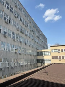
GEOSPACE completed extensive 3D laser scanning of the buildings of the Faculty of Mining, Geology and Petroleum Engineering and the Faculty of Food Technology and Biotechnology at the University of Zagreb. More than 2,000 scan positions covered over 13,000 m² of interior space, capturing billions of points.
Project Description:
The project involved detailed documentation of the existing conditions of the faculty buildings using 3D laser scanning technology. The resulting high-precision point cloud records the buildings’ spatial geometry and provides a reliable foundation for subsequent design and analysis.
The captured data supports BIM modelling and provides a basis for planning future renovations, energy efficiency upgrades and effective facility management.
Project Objectives:
accurately document the existing conditions of the faculty buildings,
create a digital foundation for BIM modelling,
provide spatial data for planning renovations and energy efficiency upgrades,
support long-term building maintenance and facility management.
Surveying Works:
The project included:
3D laser scanning of the buildings from more than 2,000 scan positions,
detailed capture of over 13,000 m² of interior space,
collection and processing of billions of spatial points,
integration of the captured data into a high-precision point cloud.
The resulting point cloud provides a detailed view of existing conditions and a shared spatial reference for designers and other specialists involved in future building works.
Project Significance:
Digital documentation of the faculty buildings provides a reliable basis for their renovation, maintenance and future development. Through 3D laser scanning, GEOSPACE supports design decisions informed by accurate spatial data and contributes to the digital transformation of the existing building stock.